Videos
Construction and Development of a Marcellus Shale Well Pad
Time-lapsed video on the construction and development of a Marcellus shale well pad
The development of a Marcellus shale well pad may take months to plan, clear, construct, drill, frac and complete for natural gas production. This time-lapsed video developed by Seneca Resources provides an educational opportunity to see the steps involved in bringing a natural gas well into production.
Maps and Graphics
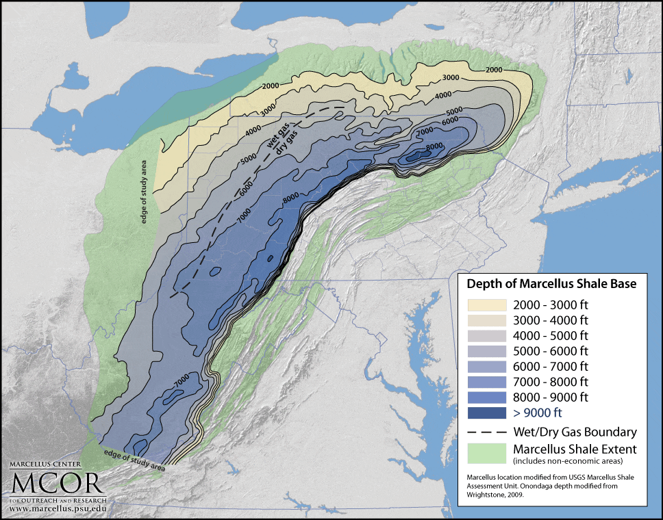
Depth to Marcellus Shale Base
The Marcellus shale occurs as deep as 9,000 feet below ground surface. At greater depths, the overlying rocks cause greater pressure in the Marcellus formation which can result in higher production rates if properly stimulated. In general, with greater depth, the natural gas contains higher proportions of methane and less “wet” gas components, namely propane, butane and ethane.
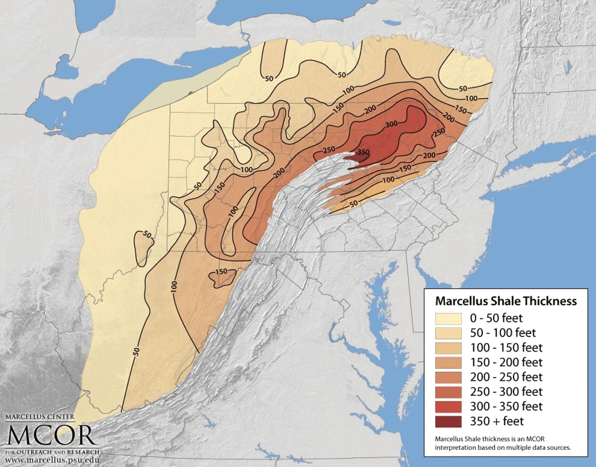
Thickness of Marcellus Shale
The organic-rich, gas-producing layers of the Marcellus shale range from less than 5 feet thick to more than 250 feet thick.
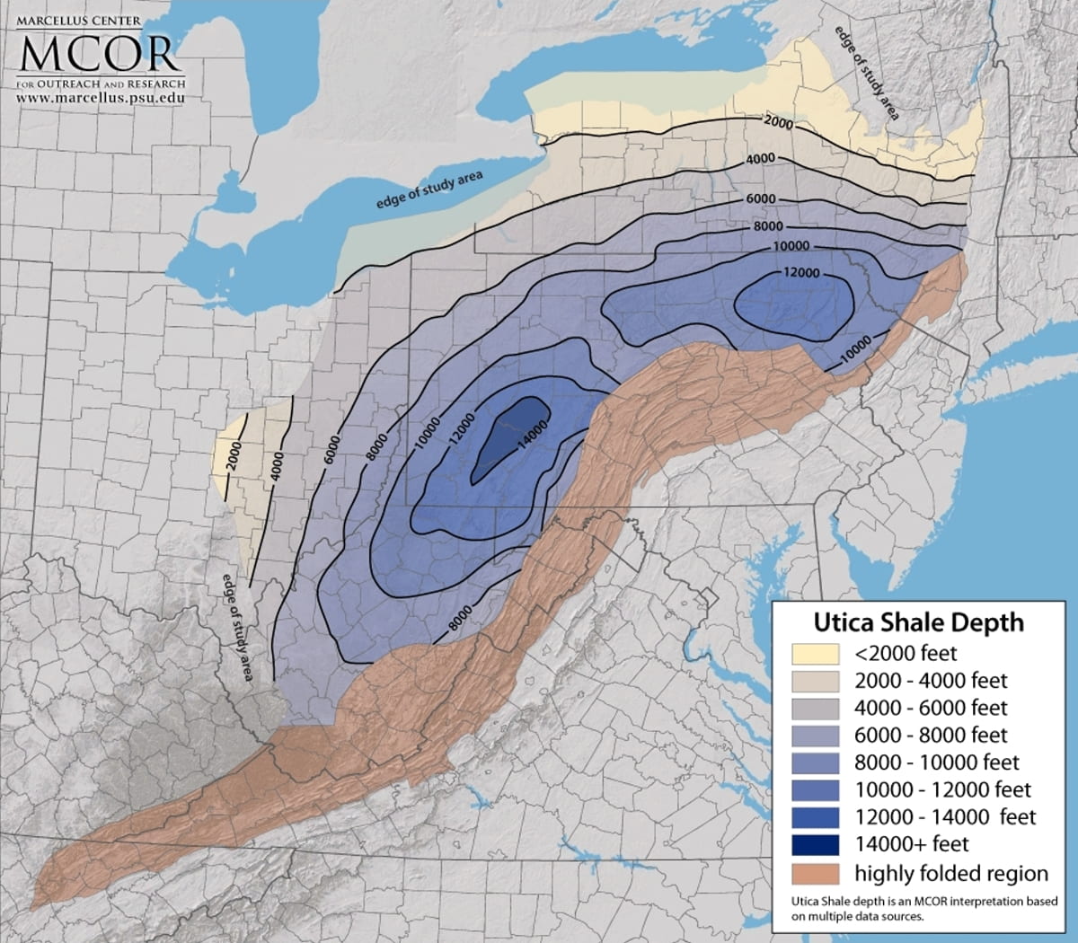
Depth to Utica Shale
Generalized map showing depth to the top of the Utica Shale. To the north in New York state, the Utica Shale equivalent is exposed at the surface. To the west, beyond the study area in Ohio, the Utica Shale is at a relatively shallow depth and has not generated hydrocarbons.
feet thick to more than 250 feet thick.
Thickness of Utica Shale
Thickness of Utica Shale and equivalents in the area of study. The thickness estimates include relatively organic-carbon rich intervals above and below that are capable of generating hydrocarbons (gas, condensate and oil) with sufficient burial and heating.
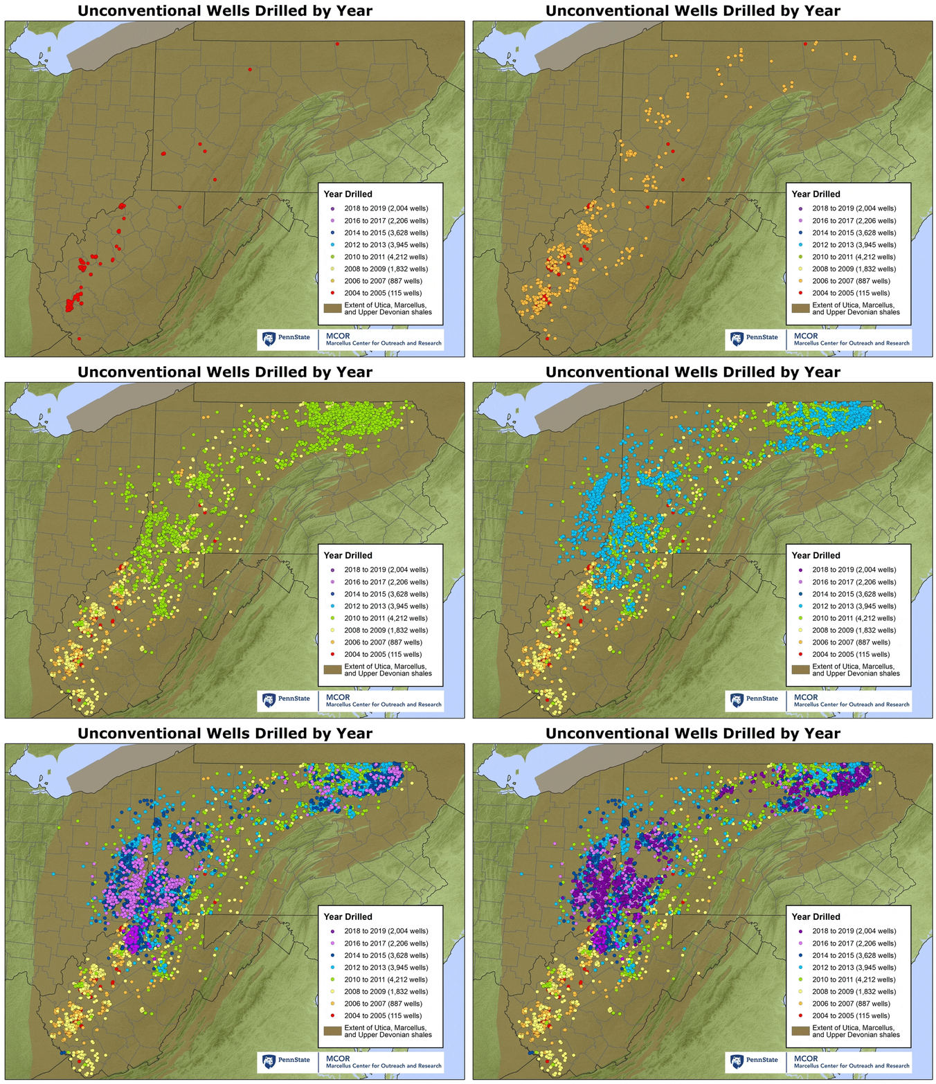
Animation of Tri-State Shale Wells
Click on the map in order to see the animation of shale wells drilled in Pennsylvania, Ohio, and West Virginia from 2004 to December 31, 2019. Data from the Pennsylvania Department of Environmental Protection, West Virginia Department of Environmental Protection and Ohio Division of Oil and Gas Resources. Click on image below to view static map.
Wet-Dry Gas
The components that make up natural gas in Pennsylvania can vary based on the “thermal maturity” of the gas, which depends on how much temperature and pressure the geologic formation experienced over time. Natural gas is known as being dry or wet, with dry gas being more thermally mature and consisting primarily of methane, whereas wet gas is less thermally mature and may contain “natural gas liquids” including ethane, butane, propane, and pentane. These natural gas liquids need to be separated from the methane to ensure the natural gas sent to consumers has a consistent BTU content. Wet gas is currently considered to be more valuable in the marketplace as the natural gas liquids have inherent value as a commodity. In the Marcellus Shale, the natural gas varies from wet in the western portion of the state and to dry in the northeast as shown on the map.
Geologic Cross Section
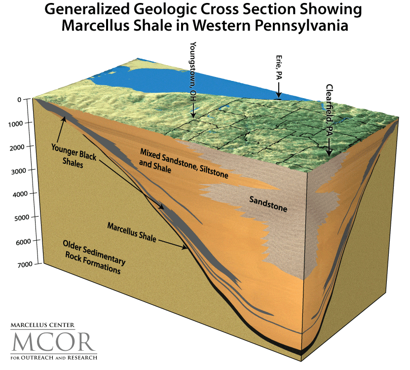
This geologic cross section depicts the extent and depth of the Marcellus Shale near Clearfield, Pennsylvania. Found as deep as 9,000 feet below the ground surface in northeastern and central Pennsylvania, the Marcellus Formation generally becomes shallower at depths of 2,000 feet toward northwest Pennsylvania. The Marcellus Shale covers 6 states and underlies nearly 75 percent of Pennsylvania. Click image to see larger version.
Major Gas Pipelines and Gas Storage Areas in Pennsylvania
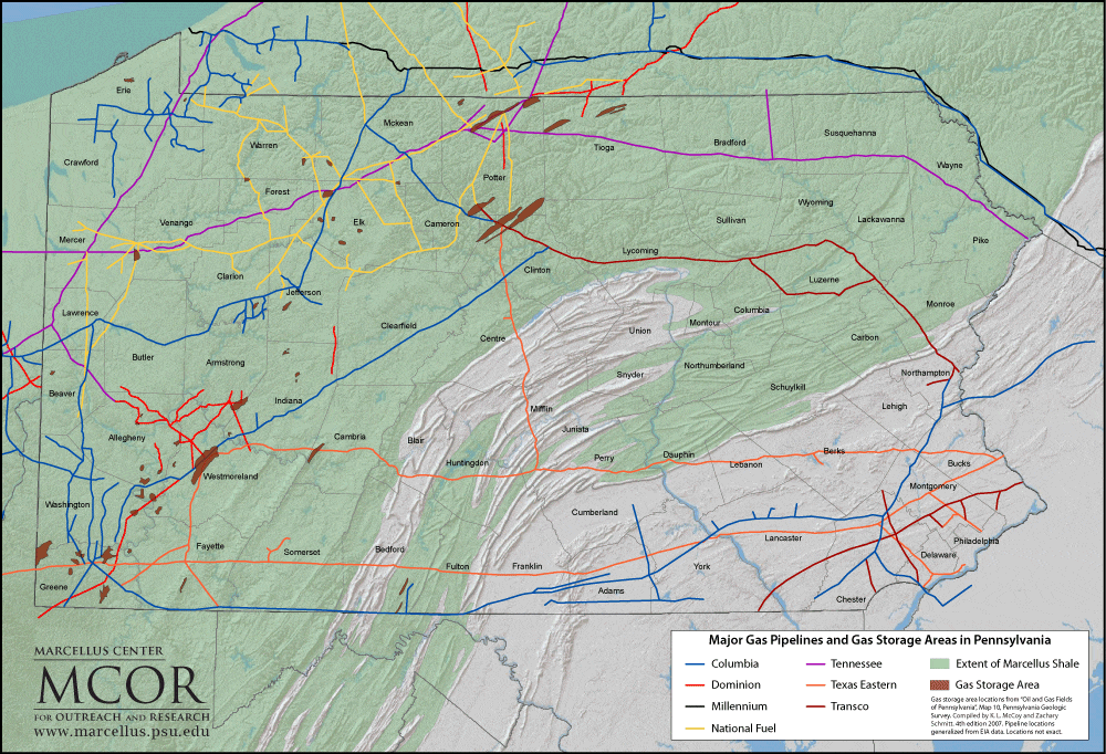
A network of natural gas pipelines transport methane from areas of active production to a variety of end users such as residences, industries, and power generation facilities. Some areas of Pennsylvania are used to store natural gas in deep sandstone formations during periods of surplus so it can be withdrawn later to meet peak demands.
Cross-Section of Typical Horizontal Marcellus Well
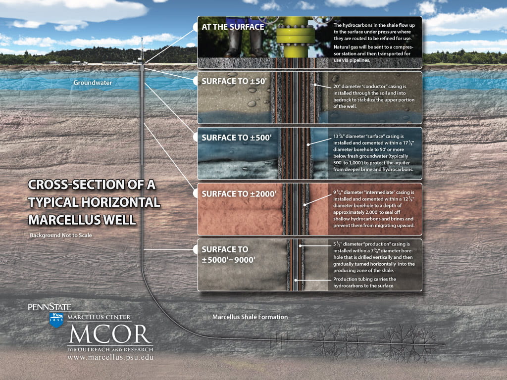
The process involves starting with vertical drilling followed by horizontal drilling. Vertical drilling ranges from 5,000 feet to 9,000 feet below ground depending upon the depth and thickness of the gas reservoir. When the Marcellus Shale is reached, the well is turned, and horizontal drilling occurs for another 3,000 feet to 10,000 feet or more. At various depths, multiple lengths of steel casing are cemented in place to protect surface water, groundwater, or water supply wells from the potential migration of natural gas in the drilled well. These casings also prevent hydrofracing fluids and deep brine water from leaking and adversely impacting water resources.


